


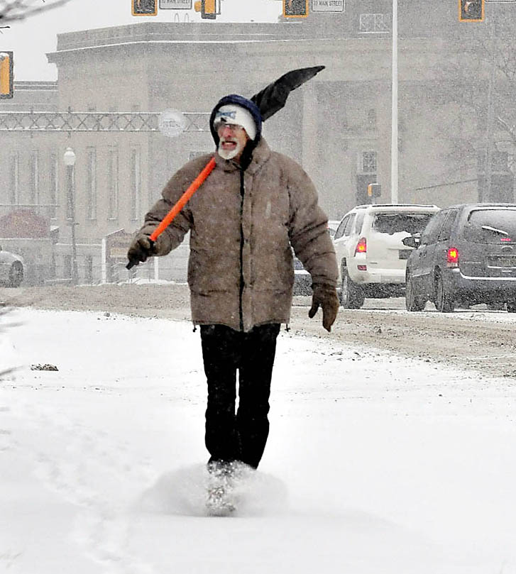
Steady snowfall is blanketing central Maine and is expected to dump 10 to 14 inches of snow on the region today and more snow is forecast later this week.
“There haven’t been any changes in the forecast,” Eric Schwibs, a meteorologist with the National Weather Service in Gray, said Tuesday. “This is going to be a long drawn-out event.”
Additional Photos


In addition to the Tuesday storm, there is potential for another 4 to 8 inches of snow on the second day of spring on Thursday, said Mike Kistner, a meteorologist at the National Weather Service in Gray.
“It is definitely different than last year when we were all out golfing and going to the beach,” said Kistner. The two storms predicted for this week are more in line with normal weather patterns for March and should add to the area’s seasonal snowfall levels, he said.
Ethan Austin, spokesman for the Sugarloaf ski resort, said this season has been great. Already, Sugarloaf is about 25 percent ahead of last year in lift ticket sales and 30 percent ahead in revenue. He said the goal every year is to keep trails open until May.
“It’s looking good. I don’t think people are sick of winter yet,” he said.
Darcy Morse, spokeswoman for the Sunday River ski area, said any big storm is good for the ski business. She said this season’s storms have been particularly well-timed.
Sunday River is about 20,000 skier visits ahead of last year’s pace, she said, and last year was the resort’s second strongest financial season on record.
On Monday, public works crews, schools and local businesses prepared for the worst. Workers at the John Charest Public Works facility in Augusta were bracing for the storm by checking equipment and loading salt into trucks, said Street Superintendent Jerry Dostie.
Dostie said it has been an average year for road maintenance crews in the Augusta area, and they are on track to spend the amount of money expected for the year.
“Obviously we wish it was rain, but overall it looks like a normal winter,” he said. Equipment usage and overtime pay for workers were at normal amounts, he said.
The intensity of the storm should pick up around midafternoon Tuesday with snow continuing until around 2 or 3 a.m. Wednesday in areas including Waterville, Augusta, Skowhegan and Farmington, Kistner said.
Most places will receive around a foot of snow, but there could be spots that get more, he said.
Temperatures will be in the mid- to upper 20s with lows in the upper teens at night, said Kistner. Conditions should improve Wednesday, he said, but it will still be chilly with temperatures in the low to mid-30s.
“The conditions right now are just right for one storm after another, and it is not unusual for March to see such an active weather pattern,” he said.
Workers at Central Maine Power were also preparing for the storm, said spokeswoman Gail Rice on Monday.
The area has seen a few storm-related power outages this winter but damage has mostly been kept to a minimum because of tree-trimming along power lines, she said.
“We are treating this like any other storm and have advised crews to be alert and ready in case of a problem,” said Rice. She said trucks were fueled and staffing levels checked on Monday in preparation.
Meanwhile, schools and local businesses also prepared for the predicted storm.
Ken Coville, superintendent for Anson-based School Administrative District 74, said he usually tries to decide the night before a storm is predicted whether school will be open the next day. However, recent forecasts have resulted in storms that veered off course, he said.
“We will try to decide early so people can know,” he said, adding that there are a few considerations the school district uses to decide if students will stay home, start late or be sent home early.
The timing of the storm is probably the single most important thing, he said.
“If the weather is going to be particularly unsafe during the traveling home time, between 2 and 4 p.m., that is a situation when we might have an early release,” he said.
The hazards of traveling are also affected by the time of year, including whether a storm falls before or after daylight saving time, said Coville.
“In mid-winter around December 21 or early January the darkness definitely affects the hazards of travel. Having daylight does improve conditions, although it isn’t everything,” he said.
Meanwhile, at Gifford’s Famous Ice Cream in Waterville, operations manager Carol Goldsmith said the store, which opened for the season on Friday, would wait until Tuesday morning to decide if the day’s weather is suitable for business.
“If there are just flurries, we will be open, but certainly if there is plowable snow, it doesn’t make sense to have our employees here,” she said.
Despite cold weather, sunny skies on Friday brought a good turnout for opening day last week, said Goldsmith. Gifford’s, which has five locations in the state, always opens on the third Friday in March, she said. Last year temperatures in the 70s kept them unusually busy, but normally the season starts more slowly, she said.
The weather service does not have a spotter for the Augusta area, but Kistner said Gray has received 83.1 inches of snow so far this year and Portland 88.2. Portland’s record snowfall occurred during the winter of 1970-71 when 141.5 inches of snow fell.
Staff writer Craig Crosby contributed to this report.
Send questions/comments to the editors.

Success. Please wait for the page to reload. If the page does not reload within 5 seconds, please refresh the page.
Enter your email and password to access comments.
Hi, to comment on stories you must . This profile is in addition to your subscription and website login.
Already have a commenting profile? .
Invalid username/password.
Please check your email to confirm and complete your registration.
Only subscribers are eligible to post comments. Please subscribe or login first for digital access. Here’s why.
Use the form below to reset your password. When you've submitted your account email, we will send an email with a reset code.